Add Republic As Your Trusted Source
Add Republic As Your Trusted Source
Advertisement
Updated March 7th 2026, 10:16 IST
ISRO Scientists Uncover True Cause of Dharali Flash Flood: Ice Patch Collapse, Not Cloudburst
ISRO scientists reveal the August 2025 Dharali flash flood stemmed from an ice patch collapse near Srikanta Glacier, not a cloudburst or GLOF as first claimed. Satellite data exposes new melting ice dangers in Uttarakhand's shrinking Himalayas, urging better monitoring.
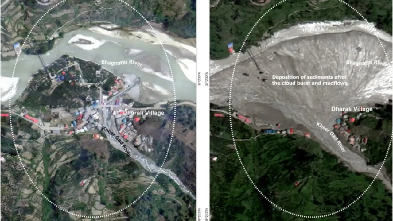
New Delhi: ISRO scientists have pinpointed the exact trigger behind last year's devastating Dharali flash flood, ruling out heavy rain and highlighting a new threat from melting Himalayan ice. On August 5, 2025, a violent rush of water, rocks, and mud slammed into Dharali village in Uttarkashi, Uttarakhand, wrecking homes, hotels, markets, and causing deaths along the Khir Gad stream before it met the Bhagirathi River. Local videos showed a quick, fierce peak flow turning into hours of thick mud, all in a narrow valley at about 2,650-2,700 meters elevation. The area's history includes past floods like 2013's big debris dump, with forests below turning to icy peaks above.
What the Study Reveals
Researchers Giribabu Dandabathula, Omkar Shashikant Ghatage, Subham Roy, Apurba Kumar Bera, and Sushil Kumar Srivastav from ISRO used satellite images, 3D terrain maps, and flood footage to trace the disaster from Srikanta Glacier's slopes to the village 9.2 km away over a 2,500-meter drop. In the high "nivation zone" - bowl-like spots above 5,200 meters where snow sticks on north-northeast slopes of 25-35 degrees - warming stripped away protective snow by June-July 2025, exposing a 0.25 square km ice patch unseen in 15 prior summers. This non-flowing mass of snow, firn (granular snow), and ice (at least 0.3 meters thick, millions of kg) collapsed suddenly around August 5, despite 80% clouds hiding full views.
Path of Destruction
The break sent ice, water, and debris racing down steeper 35+ degree slopes, scarring fresh paths and grabbing old rock piles near the base. Channel widened downstream, banks eroded, and floods spilled into Dharali, matching pre-monsoon stable channels to post-event chaos in September images. A neighbor ice patch stayed put, showing the hit was targeted.
Clash with Past Theories
Early reports blamed cloudbursts, Glacial Lake Outburst Floods (GLOFs), or landslides, but light-moderate rain August 3-5 (no burst), no upper lakes, and the surge's short peak ruled them out. ISRO contrasts this with stable past glaciers now thinning everywhere, even high clean-ice areas.
Bigger Risks and Fixes
Garhwal's steep setup funnels small releases into big impacts, like Arctic cases but new for Himalayas post-Chamoli 2021. Exposed ice signals deglaciation danger; watch via satellites (add radar for clouds) for early alerts in such zones. Needs field checks too, as no gauges or surveys limit exact volumes. Widespread Himalayan spots like this demand mapping for safety.
Published March 7th 2026, 10:16 IST